I am technologically inept. Every once in a while though I find it incredibly useful. For years, I
managed to figure out where I was going without any fancy technological stuff. We did not have the internet. We didn't have smart phones – our phones had cords and you had to dial them. If you could find a pay phone, you might be able to call for directions. Maybe you would use the CB. That often did not turn out well. I had my atlas. I had a briefcase full of city maps. Maybe some of this technological stuff is pretty good.
My favorite thing has become the satellite view. Maps and GPS take you to the mailbox. We don't deliver to the mailbox. We deliver to the dock. The dock is often around the back of a building. Drop lots can be to the side. Knowledge is good. Seeing the dock location can save you a lot of trouble
before you arrive.
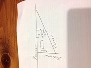
One place that I worked at is at the corner of Elizabeth and Radisson in Green Bay. The mailing address is on Elizabeth. The gate to the drop yard is on Elizabeth. At least 90% of truck drivers approached the address off of the Webster Ave. exit from I43. That means that they would have to cross
Elizabeth before they got to the gate. The GPS would be squawking at them to turn on Elizabeth. That would leave the trucker with 3 immediate options. Turn around in the employee parking lot. Turn around in the business across the street. Keep going past the address. The problem was that Elizabeth becomes no truck. The best bet at that point is to turn left at Cofrin and run the triangle back to Radisson. That adds about 2 miles and a lot more stress to the trip. Neither one are paid for. Looking at the satellite view would have prevented the problem.
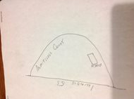
Circular Roads, common in industrial areas, also demonstrate the advantage of the satellite image. These streets often run off of more major roads. For instance, I had a customer on Armitage Court in Addison IL. Armitage circles off of Rohlwing Road (IL 53). I would be approaching from the north. The shortest route (GPS) would be to get onto Armitage at the first (north) intersection. That would put my customer on the right side of the road and force a blind side back off of the street into a tight dock. Using the satellite image, I could see that I was better off using the second entrance onto Armitage. That would add about ¼ mile to my trip, but save me a ton of aggravation.
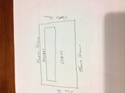
Even more common is the docks around back, on a different street. This one happened to me at the Post office in Augusta, GA. You can not get to the docks from the mailing address without going around the block with a tight turn and one way streets. Checking the satellite view has become standard operating procedure for me. Preventing problems is just easier than solving them.