Okay, so maybe I am guilty of watching way too many 1970’s trucker movies and often quoting the nostalgic trucker lingo from them. Regardless of my guilt, the type of “eye in the sky” that I am referring to is a little more complicated than a plane or chopper tracking you down the highway from overhead. As drivers, we are often faced with the challenge of taking a large truck and trailer combination into unfamiliar territory. There is nothing quite like searching for an unfamiliar address while creeping along in low gear in the pitch black of night on a dimly lit street. Even better, there is nothing better than all of that topped by the fact that when you get to that address, the truck entrance is on the other side of the block! Try this in Los Angeles like I do from time to time and you my friend will develop nerves of steel for sure.
There is one thing worth buying a smartphone for. Aside from email, text messaging, social networking, and the wonderfully mind-numbing game that is “Candy Crush Saga”, one app has saved me countless hours of hair pulling and heated-collar moments. This one app is Google Maps. Although there are a lot of map apps available, this one has personally proven to be effective in steering me in the right direction in many an unfamiliar situation. Yes, it is a mapping program, but then again, it is also so much more. Being a purveyor of technology in all its efforts to make my life easier, the “satellite view” function is perfect for what we do in our big trucks.
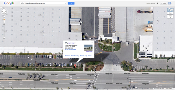
With little effort you can use the satellite view in Google Maps to get an aerial view of any address. The detail is so good for most address you can see exactly where entrances are and where the truck docks are located. Seeing the angle of the truck docks ahead of time is extremely helpful to me in scenarios where I have store deliveries and need to enter from a particular side of the shopping center to avoid having to circle the block again. In Los Angeles it is nice to view things ahead of time as well, since a lot of the addresses in our GPS units are on the opposite side of the where the truck entrances are. I use this feature to double-check my GPS routing as well from time to time. If I see that the GPS is taking me up a street with a lot of houses, I re-route myself through an industrial zone with buildings instead. I know that people are trying to sleep at 4am and like me when I am, the last thing they want to hear is an incorrectly routed truck cruising down their residential street.
Thanks to the advancements in cell phone technology and an explosion of apps available for them, you can now rest a little easier when you get sent a load assignment for one of these uncharted customers. Technology has come a long way, but by no means should it be relied on to the point past common sense!
I see too many stories of people willing to follow their technology right into the ditch because they rely too heavily upon it to do the driving for them. Be sure to carry an atlas for backup or an old Thomas Guide because you never know when technology may lead you askew. I hope like me, you too can benefit from the aerial view method that I use on a regular basis to save countless minutes of precious time and utter frustration!